Garmin GPSMAP 492 Sounder
Garmin Updated: 2008-09-17 RSS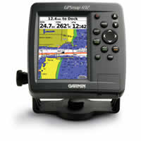
Venture offshore with the GPSMAP 492 and its counterpart, the GPSMAP 498 Sounder. With preloaded coastal maps for the U.S., the 492 is ready for action on the seas, right out of the box.
Chart Your Course
This rugged, waterproof chartplotter comes preloaded with BlueChart g2 data for the U.S. coast, including Alaska and Hawaii. This detailed map data includes 3D maps, tide and current data, improved IALA symbols, navaids, marinas, boat ramps and coastal roads. There's even a database of aerial photos, detailed roads and points of interest that you can reference for "real picture" views of harbors and marinas. The 492 can also accept preloaded data cards for additional map coverage.
Connect to Another Plotter
The 492 displays real-time tide and current information, so you can stay aware of changing conditions on the water. It also has Garmin's proprietary CANet® bus, so you can connect to another chartplotter or sounder on your boat to share information.
GPSMAP 492: Out of the box, onto the boat, off to adventure
Owners Manual
Quick Reference Guide
Flush Mount Template
Related Manuals
Garmin GPSMAP 398 Sounder
Garmin GPSMAP 498 Sounder
Garmin GPSMAP 2006/2006C Chartplotter
Garmin GPSMAP 2010/2010C Chartplotter
Garmin GPSMAP 2106 Color Chartplotter
Garmin GPSMAP 2110 Color Chartplotter
Garmin GPSMAP 2206 Color Chartplotter
Garmin GPSMAP 2210 Color Chartplotter
Garmin GSD 20 Remote Sounder
Garmin nuvi 200 Portable GPS Navigator
Garmin nuvi 200W Portable GPS Navigator
Garmin nuvi 205 Portable GPS Navigator