Garmin GPSMAP 498 Sounder
Garmin Updated: 2008-09-17 RSS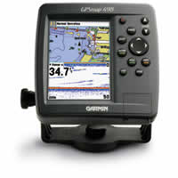
Venture offshore with the GPSMAP 498 Sounder and its counterpart, the GPSMAP 492. With a powerful built-in sounder and preloaded coastal maps for the U.S., the 498C is ready to handle any offshore fishing adventure.
Chart Your Course
This rugged, waterproof chartplotter comes preloaded with BlueChart® g2 data for the U.S. coast, including Alaska and Hawaii. This detailed map data includes 3D maps, tide and current data, improved IALA symbols, navaids, marinas, boat ramps, coastal roads and more. There's even a database of aerial photos, detailed roads and points of interest that you can reference for "real picture" views of harbors and marinas. The 498 can also accept preloaded data cards for additional map coverage.
Catch Some Fish
The 498 comes with a built-in 500-watt (RMS) sounder with enough power to track fish deep underwater, yet precise enough to perform well in shallow water as well. The sounder features Ultrascroll™ for high-speed screen updates and can show both the sonar and map on the screen at the same time. And, it can even connect to another chartplotter with Garmin's proprietary CANet® connection.
GPSMAP 498 Sounder: Out of the box, onto the boat, off to adventure
Owners Manual
Quick Reference Guide
Flush Mount Template
Related Manuals
Garmin GPSMAP 492 Sounder
Garmin GPSMAP 2006/2006C Chartplotter
Garmin GPSMAP 2010/2010C Chartplotter
Garmin GPSMAP 2106 Color Chartplotter
Garmin GPSMAP 2110 Color Chartplotter
Garmin GPSMAP 2206 Color Chartplotter
Garmin GPSMAP 2210 Color Chartplotter
Garmin GSD 20 Remote Sounder
Garmin nuvi 200 Portable GPS Navigator
Garmin nuvi 200W Portable GPS Navigator
Garmin nuvi 205 Portable GPS Navigator
Garmin nuvi 205W Portable GPS Navigator