Garmin GPSMAP 540/540s Chartplotter
Garmin Updated: 2008-09-17 RSS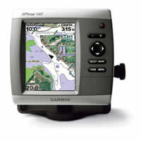
This offshore mariner's chartplotter flush-mounts easily in your boat and sports preloaded BlueChart g2 maps for the coast of the U.S. and Bahamas. The GPSMAP 540 also features a 5” QVGA display and simple, straightforward buttons and menus. You can add the optional BlueChart g2 Vision SD™ card for even more enhanced features.
Navigate the High Seas
The 540 has preloaded detailed maps covering all U.S. coastal areas and the Bahamas. For other areas, the 540 has a worldwide basemap with satellite images in place of more traditional maps. The SD card slot makes it easy to add additional maps without connecting to a computer. And with just a few buttons and a simple, intuitive interface, the 540 makes navigating your way through the water easy.
Add Sonar and Weather
Where applicable, the sounder version, GPSMAP 540s, comes with a powerful dual frequency transducer that clearly paints depth contours, fish targets and structure whether you're fishing in freshwater or off the coast. It's also CANet™ compatible, so you can share sounder data with another chartplotter on your boat. For continuously-updated weather information, you can add the optional GXM 31 antenna to receive XM satellite weather, including NEXRAD radar, and hundreds of XM radio stations right on your chartplotter.
Add Extras with BlueChart® g2 Vision
With the optional BlueChart g2 Vision SD card, you can add a whole new dimension of exceptional features to your chartplotter.
* 3D mariner's eye view or fish eye view provides you with a 3-dimensional perspective of map information, both above the waterline and below it.
* High-resolution satellite images and aerial photographs help you orient yourself in unfamiliar areas.
* Auto guidance technology searches through all relevant charts to create a route you can actually follow — one that avoids obstacles, shallow water, buoys and other obstructions.
Owners Manual
Quick Reference Guide
Flush Mount Template
Flush Mount Kit Instructions (multilingual)
Related Manuals
Garmin GPSMAP 530/530s Chartplotter
Garmin GPSMAP 525/525s Chartplotter
Garmin GPSMAP 535/535s Chartplotter
Garmin GPSMAP 545/545s Chartplotter
Garmin GPSMAP 276C Chartplotter
Garmin GPSMAP 376C Chartplotter
Garmin GPSMAP 278 Chartplotter
Garmin GPSMAP 378 Chartplotter
Garmin GPSMAP 478 Chartplotter
Garmin GPS 152 Chartplotter
Garmin Fishfinder 400C Color Sounder
Garmin Fishfinder 300C Color Sounder