Garmin StreetPilot ColorMap GPS Navigator
Garmin Updated: 2008-09-18 RSS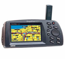
Garmin's new StreetPilot GPS was the first in the automotive marketplace to offer a comprehensive mapping system that was both portable and affordable. The StreetPilot GPS ColorMap takes up where its sister product left off by boasting a razor-sharp, high-resolution, 16-color display for easy map reading. ColorMap works in an auto, truck, or van.
Designed primarily for the automobile, the ColorMap improves on the StreetPilot's basemap information by adding exit information for the federal interstate highway system that lists available services such as food, lodging, and service stations. It also contains a reference basemap showing Interstate, U.S., and State highways, plus rivers and lakes in the US, Canada, and Mexico, with main arterial streets shown in metropolitan areas. The ColorMap is compatible with Garmin's complete line of downloadable MapSource® CD-ROMs. When paired with the MapSource MetroGuide® USA CD-ROM, the ColorMap will store 8 to 128 megabytes of downloaded CD-ROM information at a time depending on the size of the cartridge you use in the unit.
The ColorMap features a high-performance twelve parallel channel GPS receiver for quick satellite acquisition and reliable signal reception, whether you're under dense tree cover or surrounded by high-rise skyscrapers. Text and graphics are shown in large type for easy viewing, with a screen brightness adjustment and a night mode that alters the display colors for viewing in dim ambient conditions. The unit also comes with a free cigarette lighter adapter for those times when you don't have to rely on battery power.
Spec Sheet
Owners Manual
Related Manuals
Garmin StreetPilot III GPS Navigator
Garmin StreetPilot c310 GPS Navigator
Garmin StreetPilot c320 GPS Navigator
Garmin StreetPilot c330 GPS Navigator
Garmin StreetPilot c340 GPS Navigator
Garmin StreetPilot c510 GPS Navigator
Garmin StreetPilot c530 GPS Navigator
Garmin StreetPilot c550 GPS Navigator
Garmin StreetPilot c580 GPS Navigator
Garmin StreetPilot i2 Automotive GPS Navigator
Garmin StreetPilot i3 Automotive GPS Navigator
Garmin StreetPilot i5 Automotive GPS Navigator