Garmin StreetPilot GPS Navigator
Garmin Updated: 2008-09-18 RSS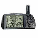
The StreetPilot GPS combines satellite tracking technology with detailed electronic maps to bring Garmin navigation to your automobile. The safety and convenience of knowing where you are anywhere in the world, in any weather, 24 hours a day is as close as your dash.
Garmin's first product designed primarily for the automobile contains a reference basemap showing Interstate, U.S., and State highways, plus rivers and lakes in the U.S., Canada, and Mexico, with main arterial streets shown in metropolitan areas. Optional MapSource® MetroGuide® U.S.A. CD-ROMs can be uploaded for street-level map detail and access to business listings and points of interest in your area. All you need to do is enter a street address or choose points of interest (such as restaurants, hotels, gas stations, banks, and shopping areas) and the StreetPilot will display it on a map along with your current location.
The StreetPilot features a high-performance twelve parallel channel GPS receiver for quick satellite acquisition and reliable signal reception, whether you're under dense tree cover or surrounded by high-rise skyscrapers. A large high-resolution four-level gray scale display offers razor-sharp images, even in direct sunlight—and with Garmin's new, three-level amber backlighting, navigating in low-light situations is easier than ever. Text and graphics are shown in large type for easy viewing with three-level backlighting for nighttime use. Six AA batteries supply sixteen hours of operation, or you can use an optional cigarette lighter adapter to power the unit. Either way, you can quickly transfer your StreetPilot to another vehicle for continuous pinpoint navigation.
Spec Sheet
Owners Manual
Related Manuals
Garmin nuvi 680 Personal Travel Assistant
Garmin StreetPilot III GPS Navigator
Garmin StreetPilot ColorMap GPS Navigator
Garmin StreetPilot c310 GPS Navigator
Garmin StreetPilot c320 GPS Navigator
Garmin StreetPilot c330 GPS Navigator
Garmin StreetPilot c340 GPS Navigator
Garmin StreetPilot c510 GPS Navigator
Garmin StreetPilot c530 GPS Navigator
Garmin StreetPilot c550 GPS Navigator
Garmin StreetPilot c580 GPS Navigator
Garmin StreetPilot i2 Automotive GPS Navigator