Garmin eTrex GPS Navigator
Garmin Updated: 2008-09-16 RSS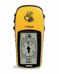
Outdoor enthusiasts, geocachers and anyone looking for adventure will love this little yellow wonder. eTrex combines intuitive, easy-to-use features and a rugged exterior into a lightweight package that is only four inches high and two inches wide. The result is a lightweight GPS navigator that literally fits in the palm of your hand.
Built for Adventure
You can operate your eTrex with just one hand using five buttons, which are located on either side of eTrex within easy reach of your fingers. Thanks to its bright yellow case, eTrex is easy to find in your boat or backpack. And, eTrex is IPX7 waterproof, so it can take an accidental splash or dunk in the water and still continue to perform.
Find It and Go
With eTrex, your adventure can last and last — up to 22 hours on just 2 AA batteries. While you roam, you can store up to 500 waypoints in memory for easy retrieval. Just enter the point you want to go to, and eTrex points you to your destination (no street or terrain maps). To get home, use Garmin's exclusive TrackBack® feature to reverse your track log and help you navigate back to your starting point.
eTrex: Find adventure. Find fun!
Physical & Performance:
Unit dimensions, WxHxD: 4.4" x 2.0" x 1.2" (11.2 x 5.1 x 3.0 cm)
Display size, WxH: 1.1" x 2.1" (2.8 x 5.4 cm)
Display resolution, WxH: 64 x 128 pixels
Display type: 4 level gray LCD
Weight: 5.3 oz (150 g) with batteries
Battery: 2 AA batteries (not included)
Battery life: 22 hours
Waterproof: yes (IPX7)
Floats: no
High-sensitivity receiver: no
Interface: serial
RoHS version available: yes
Maps & Memory:
Basemap: no
Preloaded maps: no
Ability to add maps: no
Built-in memory: no
Accepts data cards: no
Waypoints/favorites/locations: 500
Routes: 20
Track log: 10,000 points, 10 saved tracks
Features:
Automatic routing (turn by turn routing on roads): no
Electronic compass: no
Barometric altimeter: no
Geocaching-friendly: no
Outdoor GPS games: no
Hunt/fish calendar: yes
Sun and moon information: yes
Tide tables: no
Area calculation: no
Custom POIs (ability to add additional points of interest): no
Unit-to-unit transfer (shares data wirelessly with similar units): no
Picture viewer: no
Spec Sheet
Owners Manual
Owners Manual (Software Version 3.00 and above)
Quick Start Guide
Related Manuals
Garmin eMap GPS Receiver
Garmin eTrex Camo Handheld Navigator
Garmin eTrex Legend C Handheld Navigator
Garmin eTrex Legend Cx Handheld Navigator
Garmin eTrex Summit Handheld Navigator
Garmin eTrex Venture Handheld Navigator
Garmin eTrex Venture Cx Handheld Navigator
Garmin eTrex Vista C Handheld Navigator
Garmin eTrex Vista Cx Handheld Navigator
Garmin Geko 101 Personal Navigator
Garmin GPS II Mapping GPS Receiver
Garmin GPS II Plus Mapping GPS Receiver