Garmin GPSMAP 3205 GPS Chartplotter
Garmin Updated: 2008-09-17 RSS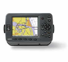
Plug into the Garmin Marine Network with the GPSMAP 3205, a 5-inch color screen chartplotter with preloaded marine maps. Whether you choose the 3205 or its counterparts, the GPSMAP 3206 and 3210, you'll get bold, sunlight-readable color, high-speed processing and the versatility of a multifunction display.
See Marine Maps in Sharp Detail
The GPSMAP 3205 comes preloaded with U.S. marine detailed maps for the entire coast of the United States, including Alaska and Hawaii. These maps are based on BlueChart g2 technology, so they layer smoothly and are integrated for easy panning, scrolling and zooming. The maps also provide a choice between 3D "mariner's-eye-view", or the familiar 2D direct-overhead view to make chart reading and orientation easier. And, with the 3205's crisp 5-inch diagonal screen, you'll get incredible contrast and detailing, even in direct sunlight.
Integrate Easily with Garmin Marine Network
The 3205 connects easily to the Garmin Marine Network, so you can interface with additional MFDs and add remote sensors and sonar. Its slim-line design makes it easy to install in cabin bulkheads or open cockpits, and its smaller size makes it work well as a secondary unit for a boat already rigged with the Marine Network. For even more options, the GPSMAP 3206 and 3210 also provide a remote control, VGA output and video input options.
Keep Tabs on the Weather
Tough enough to withstand rain, sunlight and saltwater spray, the case is fully gasketed and waterproof to IPX7 standards. Better yet, with an optional subscription to XM WX Satellite Weather™ and the addition of a GDL 30 or 30A weather receiver, you can receive up-to-the-minute weather information for the U.S. You can see detailed real-time weather patterns, including NEXRAD radar, right on the 3205's screen by connecting through the Garmin Marine Network. The GDL 30A also provides XM Satellite Radio service.
Add More Marine Maps
The 3205 accepts optional BlueChart g2 marine cartography, which brings you 3D maps, tides and currents, depth contours, navaids, port plans, marine services and points of interest (POIs). Best of all, with these optional maps, you can view real, detailed aerial photos of harbors, marinas and other important marine landmarks and places, right on your chartplotter.
GPSMAP 3205: Preloaded, detailed marine maps at your fingertips.
Owners Manual
Quick Reference Guide
Installation Instructions
Flush Mount Template
Related Manuals
Garmin GPSMAP 3010C GPS Chartplotter
Garmin GPSMAP 3206 GPS Chartplotter
Garmin GPSMAP 3210 GPS Chartplotter
Garmin GPSMAP 4008 GPS Chartplotter
Garmin GPSMAP 4010 GPS Chartplotter
Garmin GPSMAP 4012 GPS Chartplotter
Garmin GPSMAP 4208 GPS Chartplotter
Garmin GPSMAP 4210 GPS Chartplotter
Garmin GPSMAP 4212 GPS Chartplotter
Garmin GPSMAP 5008 GPS Chartplotter
Garmin GPSMAP 5012 GPS Chartplotter
Garmin GPSMAP 5015 GPS Chartplotter